
Drone Altitude Hold refers to the aircraft’s ability to maintain a constant flight altitude without manual intervention. This is achieved by utilizing onboard sensors, such as barometers, ultrasonic sensors, and UAV LiDAR, to perceive the real-time distance between the drone and a reference plane (mean sea level or ground). The flight control algorithm then automatically adjusts motor speeds based on this data.
Whether for consumer-grade aerial photography or high-precision industrial operations, stable altitude control is a decisive factor in both mission success and aircraft safety.
The Role of Altitude Hold in Drone
1. Enabling Stable Hover and Flight
Drone altitude hold is the core execution layer for spatial stability. While sensors provide the data, the altitude hold algorithm (typically a PID controller) translates this information into motor commands.
- Aerodynamic Compensation: It actively counters vertical drift caused by wind gusts or the ground effect, ensuring the aircraft maintains a consistent vertical position.
- Decoupling Movement: During multi-axis maneuvers (such as pitching or rolling to move forward), the control loop ensures that vertical lift remains constant, preventing the common dipping effect during high-speed transitions.
2. Ensuring Flight Safety
Drone altitude hold is more than just staying in place; it is a key mechanism for executing vertical displacement commands in automated missions.
(1) Automated Landing and Return-to-Home (RTH)
During the landing phase of an automated RTH, altitude hold converts sensed distance data into precise descent rate control, preventing hard landings caused by gravitational acceleration.
(2) Dynamic Response in Terrain Following
In complex terrain operations, altitude hold functions as dynamic tracking control. When downward-facing sensors detect changes in ground elevation, the altitude hold system treats this variation as a height deviation signal and applies rapid power compensation to maintain a constant relative altitude above the undulating ground.
3. Improving Aerial Photography and Operational Quality
- Consumer Grade (Aerial Photography)
High-precision vertical control minimizes altitude-induced oscillations in the footage, ensuring stable framing for aerial photography and smooth time-lapse sequences.
- Industrial Grade (Operations)
- Precision Agriculture: Plant protection drones must adjust their height based on crop canopy height. Excessive height leads to chemical drift, while insufficient height may cause the rotors to interfere with the crops.
- Power Line Inspection and Modeling: When performing modeling of power grids or historical structures, maintaining a constant altitude ensures consistent Ground Sample Distance (GSD), which increases the success rate of subsequent data reconstruction.
Causes of Inaccurate Drone Altitude Hold
1. Inherent Limitations of Barometers
- Airflow Disturbance
The downwash airflow generated by the rotors directly impacts the barometer’s pressure inlet, causing severe local pressure fluctuations. Even with filtering algorithms, this interference can still cause altitude readings to drift up and down during hovering or low-speed flight.
- Thermal Drift
Barometers are highly sensitive to temperature changes. After the drone is powered on, heat generated by the motors and electronic speed controllers (ESCs) causes the internal temperature of the fuselage to rise rapidly, leading to a slow drift in barometer readings.
Even if the actual altitude remains unchanged, the displayed altitude may gradually decrease or increase.
2. Physical Limitations of Traditional Sensors
- Ultrasonic Sensors
These are limited by the physical properties of sound waves. They exhibit extremely weak echoes on sound-absorbing surfaces such as grass or sand, resulting in measurement blind zones.
Additionally, ambient noise, such as high-frequency motor whine, can cause co-channel interference, leading to data errors.
- Vision and Optical Flow
These systems depend heavily on surface texture and ambient lighting conditions.
On specular surfaces (e.g., shimmering water), in total darkness, or on uniform surfaces such as monochromatic laboratory tiles, the vision system fails to identify feature points. This loss of tracking can lead to a complete loss of altitude control.
3. Aerodynamic Interference
When a drone hovers or lands close to the ground (typically at an altitude below the rotor diameter), the rotor downwash is blocked by the ground, creating an air cushion.
This effect alters the airflow field around the drone, confusing the flight controller’s altitude estimation algorithm. Even when the drone is actually descending, the barometer may misinterpret the airflow rebound as a constant or even rising altitude.
Potential Consequences of Inaccurate Drone Altitude Hold
1. Mission Failure and Property Loss
Inaccurate altitude hold prevents the drone from executing automated missions as intended, leading to missed waypoints, incomplete coverage, or premature mission abortion.
For missions involving spatial data collection, vertical instability creates gaps or distortions in the captured data that cannot be corrected during post-processing, rendering the entire dataset unusable.
2. Aircraft Loss and Crash
Incorrect altitude data is a major cause of drone crashes.
If the flight controller reports sufficient altitude while the drone is dangerously low, the operator may misjudge the distance and inadvertently cause a ground impact.
In contrast, should the system mistakenly perceive the altitude as too low and trigger an automatic climb, the aircraft risks colliding with overhead obstacles.
3. Hardware Structural Damage
Repeated hard landings caused by inaccurate altitude hold accelerate wear and fatigue of structural components such as landing gear and gimbal vibration-damping balls.
More critically, if the gimbal cannot fully absorb the impact upon touchdown, the shock may be transmitted directly to the camera lens or gimbal motors, resulting in damage to expensive imaging equipment.
Benewake Solution for Accurate Drone Altitude Hold
Our Benewake LiDAR solutions are purpose-built to address the real-world challenges outlined above, delivering precision, stability, and environmental resilience.
1. Key Advantages
- High Ambient Light Immunity: Operates stably even in strong outdoor sunlight at noon, overcoming the failure of vision sensors in backlit or high-light conditions.
- High Protection Rating: Industrial-grade dustproof and water-resistant sealing, suitable for harsh environments such as agricultural spraying and power line inspection.
- Multiple Interface Support: Provides UART and CAN bus interfaces with support for various baud rates, facilitating integration into different flight controller platforms.
- Built-in Temperature Compensation: Corrects the effect of ambient temperature changes on distance measurement through internal algorithms, ensuring accuracy and stability across the full operating temperature range.
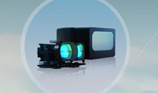
2. TFA300 Series
The TFA300 series, including TFA300 and TFA300-L, is engineered for industrial drone applications
Under 90% reflectivity conditions, the maximum detection distances reach 270 meters and 290 meters, respectively. Even on targets with only 30% low reflectivity, reliable ranging of 150 meters (TFA300) to 170 meters (TFA300-L) can still be achieved.
Applicable Scenarios: The TFA300 series is particularly suitable for applications requiring long-distance, high-precision ranging, such as mapping, power line inspection, and security surveillance.
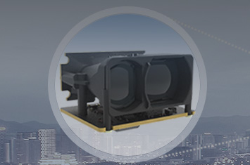
3. TFA170-L
The TFA170-L is a long-range single-point LiDAR sensor designed for drone platforms that prioritize lightweight design.
Weighing only 10 grams and consuming no more than 1 watt, this LiDAR sensor provides a detection range of up to 170 meters with 1-centimeter resolution, delivering reliable long-distance measurement to drone developers while minimizing the payload burden.
Applicable Scenarios: The TFA170-L is an ideal choice for consumer-grade aerial photography drones and small industrial drones requiring precision landing and indoor positioning.
Conclusion
From aerial photography to precision agriculture to infrastructure inspection, the reliability of altitude perception directly determines mission success and aircraft safety.
At Benewake, our drone altitude-hold sensors deliver centimeter-level precision, superior anti-interference performance, and industrial-grade durability.
Ready to elevate your drone’s altitude hold performance? Explore Benewake’s full range to find the optimal LiDAR for your UAVs.